Tuesday, February 22, 2011

North to Alaska 2010

Another travel day in the Yukon Territory
Still heading east and the day starts out overcast and cold once more. At least there is not the uncomfortable rain to contend with.


I know I posted a picture of the wooden police car in Destruction Bay but I think the concept of a constant reminder of some type of coverage is worth another glance. This has to be cheaper than a police force and maybe in some instances as effective.


We stopped at the Sheep Mountain Visitor Center and counted at least 30 sheep on the mountainside. This center was closed for the winter. The southern slpes of Sheep Mountain are the primary winter and spring range and lambing area of a Dall sheep population. Rams migrate out of the area in May. Females with lambs may be seen from early May to early June. Sheep return to the mountain in September. The fact of Sheep Mountain has been designated a special preservation zone.


We had stayed at the Congdon Creek Yukon government campground on Kluane Lake when heading into Alaska but we passed this up to stay in Whitehorse - at where else but a Walmart.


We spotted one of the several Eagles we have seen this summer at Sulphur Lake along the highway but by the time I got my camera out and ready he had moved to a tree.


I can't see him either!


Again we noticed there was fresh fallen snow on the Kluane Mountains. It is beautiful and it certainly won't be long before the snow falls on the lower elevations and winter will have come once more to the northwestern part of North America.


It will be a steady time of travel until we reach the lower 48 - Washington to be exact. With the colder temperatures and the threat of snow we don't want to be caught in a storm. We have asked several people that have traveled to Alaska and some of the residents and they all advise taking the western route - the Cassiar Highway - down into British Colombia because of the threat of snow on the eastern side of the mountains and being smart people, that is what we will do. Hopefully within a couple of days we will be wending our way south on the Cassiar with new vistas to admire.
Some parting pictures.


Kluane Mountain Range


Do-it-yourself truck camper


North to Alaska 2010

Leaving Alaska - heading out

We spent 10 days total at Deadman Lake and when the day came to leave, Ken and I were both sad to be leaving. Alaska is the only state we have been in that I felt sad to leave. The state is beautiful - wild, barren, majestic with a largeness about it that is unsurpassed. If we were younger we would seriously consider moving there - for the summers only!! I don't think we could take the -75 degrees and 24 feet of snow at this point in our lives.

The weather today is cold and rainy - but then again, what else is new!? There is only one way into Alaska so we know what the roads are going to be like - bad, bad, bad. Of course, if you slow down to about 15 or 20 miles per hour they are drivable. Again we are crossing the US/Canadian Border at Port Alcan and the frost heaves are still there! Darn - with all of the construction on this highway we had hopes that they had smoothed them out.


Next stop is Beaver Creek, Yukon Territory - population is 112. Beaver Creek is 1 of 2 sites where Alaska Highway construction crews working from opposite directions connected the highway in October, 1942. Our Lade of Grace mission was built in 1961 from a salvaged Quonset hut left over from highway construction days. It is 1 of 3 Catholic missions on the north Alaska Highway - the others are in Burwash Landing and Haines Junction.


We stopped for the night in a rest area just before Destruction Bay - population 55. Located on the shore of Kluane Lake, Destruction Bay is one of several towns that grew out of the building of the Alaska Highway. It earned its name when a storm destroyed buildings and materials here. Destruction Bay was one of the many relay stations spaced at 100-mile intervals to give truck drivers a break and a chance to repair their vehicles. A repeater station was also located here, providing telephone and telegraph service. There is still a highway maintenance camp here.
Miles traveled today were 165.4 - Most of the way overcast. Tomorrow is another day and hopefully it will be better without any rain.

Monday, February 21, 2011

North to Alaska 2010

Deadman Lake Memories

While we were at the campground this time we were fortunate to meet some Athabascan Indian women who were kind enough to share bits and pieces of their culture with us. Having native bloodlines in my heritage, this is and always has been fascinating to be able to learn more about a lifetime that has long since passed but only in the eyes of modern society. Native Americans still practice the ways and teachings of their forefathers and continue to pass these gifts down to their children and grandchildren.


Rather than continue to put words on this blog, I am going to share some pictures of the lake and surroundings. Enjoy


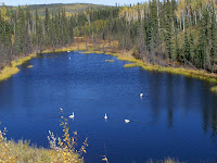
The last of the swans - swimming and catching their dinner


Lichens to the left - the Wrangle Mountains to the right with the terminal snow on the top. This is the light dusting of snow that signifies that summer is over and winter is on its way. The natives don't pay attention to the weathermen - they just watch the mountains. Seems right to me!


North to Alaska 2010

Deadman Lake Revisited
Passing through Tok we realized that a lot of the summer visitors have departed already. The businesses are still operating but on a limited schedule and the terrain all along the highways the last few days show signs of summers end.


Arriving at Deadman Lake brought back a lot of good memories from the beginning of our time in Alaska - wildlife teeming, lots of birds and waterfowl and beautiful wildflowers edging the roads. Alas, the lake hasn't changed much other than the fact there are very few birds and waterfowl and the level of the lake has dropped. The campsite we liked was empty as were most of the campsites.


The first night in the campground we went up for the ranger talk which was led by Cora Demit - an Athabaskan Indian Woman who is the Senior Ranger and a Tribal Council Member. She talked about life on the wildlife refuge and how the natives have survived throughout the years. She was a very interesting woman and we learned a lot about the Athabaskan Culture.

The second day there we went to the Indian Village - Northway Village - about 10 miles from the campground. The road into the village is narrow and winding, traveling over streams and barren land. The village itself is very small and most of the houses are of the same style and construction - a square structure up on stilts. Some of them larger than others but for the most part looked from the outside only 4 rooms to a house. Most of them still had outhouses as they have no sewer system. I did not take any pictures out of respect for their culture and privacy. We stopped at the post office and talked to a young woman there - Cherie Merandi - who gave us a lot of information about the drug and alcohol problem and how the Athabascan tribe is trying to help their people get away from that temptation. She also told us about the job situation in Alaska and about what her kids experienced working on the North Face. He daughter worked cleaning the rooms and showers for over $100 a day. Her son worked there laying pipe and whatever else they do for double that amount. Not too bad if you want to work. The people that work on the North Face work for 2 weeks and they are off 2 weeks. The mode of transportation in and out of the area is by plane and most of the workers live in the lower 48 states. They make good money but it is hard work and dangerous. Cherie was kind enough to show us her beading skills. She is making a rifle strap and it was beautiful work. Certainly peaked my interest.
The second night the ranger talk was led by Cheryl - another Athabaskan Indian woman - and
she talked about the plantlife in the wildlife refuge. She brought us Labrador Tea plants and spruce branches and instructed us on how to make the tea. She said that her mother drinks a cup a day and has her whole life and that is what keeps her healthy. She gave me the plants she had brought - we were the only ones there - and of course I had to make the tea. She said if I could find some cranberries I could put that into the mix too - so I did. I will say this for the mix - it definitely made our trailer smell good what with the spruce branch in it. Ken drank the tea and liked it - I thought it tasted like pine sap. After a couple of glasses of the tea Ken suggested we add some water to it as perhaps it was too strong so I did and it made it much more palatable.

The third day we went on a hike to Hidden Lake. Along the way we spotted low bush cranberry plants, loaded with berries and decided we would pick on the way back. This trail is about 1 mile long and a lot of it is on constructed boardwalks because of the low areas that fill with water. The lake is small but we spotted beavers working diligently to supply food to the beaver family for the winter. There were two adults swimming back and forth bringing branches with them on the return trip and the kits - baby beavers - were practicing their skills maneuvering in the water - diving, playing and just swimming. They were so cute!! On the way back we did stop and pick cranberries - these low bush cranberries are actually loganberries - much smaller than the bog cranberries that we are familiar with. We also picked a few left over blueberries and ate them as we picked.
The third night ranger talk was given by Sylvia. She talked to us about "Potlatch" which is what they call their beading. She was very informative and told me she would give us some moose if she had any left in her freezer along with some whitefish preserved the native way if we came to the visitor's center the next day.
We did go to the visitor's center for Tetlin National Wildlife Park the next day and Sylvia blessed us with 4 slabs of fish and a large piece of moose tenderloin. Can't wait. While at the center, Cheryl took me to the demonstration table and showed me how they do their beading. Guess I will have to make a trip to a bead supply place - which she told me where to go - and buy some supplies.

All in all, the last 4 days have been wonderful. The nights are getting cooler and the lake is getting quieter with the waterfowl that was there starting their migration. We will remember Deadman Lake with wonderful memories and look forward to again spending time on the next trip.
This is the only moose we have seen in the last two weeks. A planter on the porch of the Tetlin National Wildlife Refuge Visitors Center

North to Alaska 2010

Heading back towards Deadman Lake

We are continuing on the Glenn Highway toward Tok and Deadman Lake where we plan on staying for a few days.

There are many small towns in Alaska and some of them have some really strange names - most likely related to a way of life or happening back during the gold rush. One such town is Chickaloon which has a population of 282. It was established around 1916 as the terminus of an Alaska Railroad spur, and currently serves as a stop for motorists and river rafters. Chickaloon has a post office, gas, diesel, cafe, bed-and-breakfast, cabins and camping. The Matanuska River closely parallels the Glenn Highway and this is a perfect place for the Nova River Runners to offer scenic floats and whitewater trips on the river. The Matanuska River is formed by its East and South forks and flows southwest 75 miles to the Knik Arm of Cook Inlet.

Along the Glenn Highway are expansive views of King Mountain and the Matanuska River. There are several signs warning to "Watch out for Moose" but as Moose hunting season started on August 25th, there are no signs of any of those cumbersome animals.

One stop along the way was to view the Matanuska Glacier that heads in the Chugach Mountains and trends northwest 27 miles. Some 18,000 years ago the glacier reached all the way to the Palmer area. The glacier's average width is 2 miles; at its terminus it is 4 Miles wide. The glacier has remained fairly stable the past 400 years. At the glacier terminus meltwater drains into a stream which flows into the Matanuska River.
We passed over the Caribou Creek which is a Recreational Gold Mining Area. Recreational gold panning, mineral prospecting or mining using light portable field equipment - e.g. hand-operated pick, backpack power drill, etc., is allowed in these designated areas on state lands without mining claims. This Caribou Creek heads at a glacier terminus in the Talkeetna Mountains and flows 35 miles southeast to the Matanuska River. I tell you this because there are 26 creeks named Caribou Creek in the Dictionary of Alaska Place Names. From this information it appears that Caribou Creek was a favorite and popular name.

We spent the night just past Glennallen on the Glenn/Richardson Highway junction. Tomorrow we will pass through Tok and again end up at Deadman Lake.

Thursday, February 3, 2011

North to Alaska 2010

Heading East and South

We took Jason to the Anchorage International Airport today - August 25th. We had a wonderful time while he was with us and Ken and I were both sad to see him go. Now it is time to start the trek to head out of Alaska and down to the lower 48 states.

After leaving the airport, we headed across towards the Glenn Highway which goes through Palmer and connects with The Richardson Highway and then to the Tok Cutoff. This route will have us traveling on the eastern side of the Denali National Park.

Palmer has a population of 5,574. This nice little community is both a bit of pioneer Alaska as well as a modern-day commercial center for the Matanuska and Susitna velleys - collectively referred to as the Mat-Su Valley. Palmer was established about 1916 as a railway station on the Matanuska branch of the Alaska Railroad. Before that, the area had long been used by Athabascan Indians and starting in 1890, the site of a trading post run by George Palmer. In 1935, Palmer became the sit of one of the most unusual experiments in American history: the Matanuska Valley Colony. The Federal Emergency Relief Administration, one of the many New Deal relief agencies created during Franklin Roosevelt's first year in office, planned an agricultural colony in Alaska to utilize the great agricultural potential in the Matanuska Valley, and to get some American farm families - struck by first the dust bowl, then the Great Depression - off government help. Social workers picked 203 families, mostly from the northern counties of Michigan, Wisconsin and Minnesota, to join the colony, because it thought that the many hardy farmers of Scandinavian descent in those 3 states would have a natural advantage over other ethnic groups. The colonists arrived in Palmer in the early summer of 1935, and though the failure rate was high, many of their descendants still live in the Matanuska Valley.


We had been in Palmer on our "inward" trip to the Kenai Peninsula when we took the trip over the mountain from Wasilla in July so we didn't see any need to stop for anything. Instead we continued on up the Glenn Highway and then the Old Glenn Highway until we came to the Knik River Recreation Area. John and Fran were staying there for the night and as it was getting late, we found a spot and set up for a night or two.


The Knik River Recreation Area is basically a gravel moraine along the Knik River that is utilized heavily by ATM's and dirt bikes. There are mountains surrounding the area and it is beautiful, but if you are looking for a peaceful spot by the river - forget it. They are out on their toys early morning until late at night. Thankfully, it was a week night and there were only a couple groups there and they left the following morning - along with John and Fran. They are heading back to Denali National Park and that area to meet up with some friends. We most likely won't see them again until after the first of the year when we are all in Arizona. Ken and I stayed two nights in this area before heading back out on the Richardson Highway.
A note about the pictures - I didn't take too many on the way to the Knik River Recreation Area as it was getting dark and also because the area from the airport to the recreation area is mostly suburban sprawl - lots of houses and businesses. The rock however was something that made me giggle. It was the size of a good baking potato and had it not been for the fact that rocks get heavy the more you collect, I left it there instead of brining it with me. Darn! I love rocks!!

Thursday, January 6, 2011

North to Alaska 2010

Salmon Fishing on the Kenai Peninsula

Salmon fishing in Alaska is almost like a national holiday for the natives - and some visitors to the state. While we were parked in Soldotna we met many people that were there just for the salmon fishing. We were amazed at the length to which these people took this sport - and the end results. Most everyone was equipped with methods to preserve their catches. Many of them had canning equipment and freezers that they incorporated into their RVs, some of them taking out their furniture to install the freezers so they could take hundreds of pounds of salmon back to the lower 48 with them.

First salmon season is for the "king salmon". These fish are huge and supposedly the Filet Mignon of the line. Then comes the "reds" - or as we know it Sockeye. These are nicknamed appropriately as the flesh is dark red. Third coming are the "Silvers" - or Coho. Following this is the "pinks" or what they call Dog Salmon. This salmon is what we get in our canned salmon here in the states unless it is actually called Sockeye on the label. The natives or residents take these salmon out of the water with the only intention being of taking it home and grinding it into dog food - hence the name "dog salmon".

Ken and I didn't participate in any fishing, but while Jason was with us, he did go fishing and had a great time. We met a couple of guys that clued us into the technique and the fact that you can actually eat the pinks if you catch them at the right time. You don't want to keep the males - they are usually past their prime and some of the females are too. What you have to look for is the silver sheen on the sides of the females - if it is there, they haven't been in the water too long and are every bit as good to eat as any of the other salmon. We can vouch for that as Jason caught a huge one and we took it back to the RV and cooked it that night. It was delicious - just as good as the sockeye we had before.

There are dangers in salmon fishing also. Most everyone fishes in the rivers. The Kenai River is one of the most dangerous bodies of water in Alaska. It is cold, deep and very fast moving. Very few fishermen go out in boats, opting to stand a foot from the bank and casting their lines out into the current. They do this over and over again. Also, they have no bait on the hook - only a fly of some sort. A lot of the fishermen tie a red piece of red yarn to the hook and call it a fly. Surprisingly, that works just as good as any store bought fly.


The day we got to the Soldotna area there was a 42 year old man - in good health - that was fishing the Kenai. He lost his balance, the bystanders saw him go down, surface once and they pulled him out two days later. Another time, one of the women that was fishing from our camping area also lost her balance and started floating out into the current. One of the guys that was close to her caught her by the hair and pulled her back in. She was fortunate but it scared her and she told Ken that she didn't think she was going to fish any more. This woman was 80 years old, only about 5' tall and had been fishing in this spot for 30 years or more. This picture at the left is just to say - "Where there is salmon there is a bear somewhere!"

One of the campers in the Soldotna area canned 12 cases of pint size jars of salmon. When they were done with that method they took their salmon to one of the town fisheries to have them flash frozen and vacuum packed to load in their two freezers. The freezers were in the back of a utility trailer and they kept them running with their generator. They had been there most of the summer before we got there and had been fishing almost every day. All of them say they eat salmon 3 or 4 times a week and while they are fishing they eat salmon every day. I like salmon but only about once or twice a month!! That is healthy enough for me!

We will be leaving this area in a couple of days to take Jason to the airport in Anchorage to fly back to Pennsylvania. Once we take him to the airport we will be heading east and starting our trip back to the lower 48 states. I, for one am not looking forward to leaving this amazing state. It is the only state I have been in that I am actually sad to leave. That must mean I will be coming back to Alaska at some point in the future.


Finally - a good picture of Mt. Redoubt - the volcano!


Beautiful moonlit Alaskan night!