Friday, May 28, 2010

North to Alaska 2010

North Dakota - Montana

We thought we would be stopping at the Theodore Roosevelt National Park for the day and spending the night in the National Campground but because of the tire problem, we opted to keep going and save this national park for another trip. We did, however stop at the Painted Canyon which is at the very eastern side of the park. Words do not describe the sheer beauty and magnitude of this area. Pictures do not do it justice either.


The red color you see on top of the "hills" is caused from lignite coal burning below ground. You can't actually see anything burning - smoke or flames - but it is there. It is easy to imagine how hard it would be to find your way out of this area. The Painted Canyon is also known as the Badlands of North Dakota.
Throughout this area the hills are starting to show conical mounds and buttes. The ranches are vast - with about 30 miles between them. After the National Grasslands, the hills flatten out from high rollers to long grades - still very pretty.
We have seen a herd of Mule deer and several Pronghorn Antelopes as we travel through this area and the further west we go, the more stark and desolate it becomes.

Tomorrow we will enter into Alberta, Canada - a new province for us.


North to Alaska 2010

Minnesota and North Dakota
Leaving Michigan, we have traveled through Wisconsin, Minnesota - Bemidji - birthplace of Paul Bunyan and Babe the Blue Ox
and now into North Dakota - a new state for us. We stopped at Rugby, ND - the Geographical Center of North America.
We spent last night in Saginaw, Minnesota and tonight we are staying in Michigan City, ND. The weather has been great, the land is getting more interesting and we are enjoying ourselves and each other as we travel west.

We stopped at the Lewis and Clark Interpretive Center to see the Hiditsu Indian Villages. This is
where Sakajawea came from. However, in going through the center we learned that her name is actually pronounced - Sa-KA-ka-WE-a. The Hiditsu tribe do not have a gee or ja sound in their language. Interesting how the white man has twisted things through non-understanding.


The villages are no longer, but the circles are there where the mounds were. This is one of the tribes that did not live in tipi's. They built these huge earthen structures - wood frame on the inside with 12" of dirt and sod on the outside - that housed up to 30 tribe members. 
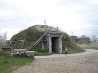
In the winter they moved down towards the Missouri riverbanks and built smaller lodges because that location was more protected in the winter weather. These lodges were usually torn down or destroyed afterwards when they moved back up on the higher level and the next winter season, they built new, smaller lodges.

There were three locations where the villages were built - one was smaller with only about 20 lodges, the other two had many more.


The lands of North Dakota are extremely interesting. When I thought of the state before, I pictured farm lands and not much of anything else. Not so! North Dakota has abundant wetlands due to Devil Lake. The water was drained to make more farmland and rerouted and what actually happened is it made more wetlands. Farmers are losing up to 1/3 of their acreage and have been trying to get the Canadian government to allow them to drain the excess water into the river. The Canadian government is totally opposed to this so guess North Dakota is stuck with the problem.

We have seen many waterfowl as we passed through - to name a few; Common Merganser, Mallard, Black Scoter, Canvasback, Northern Shoveler - all ducks - Canada Geese, Red Winged Blackbirds, 3 Pheasants, Cormorants, Blue Heron, Snow Geese, Hawks, 2 Eagles, 6 Deer and 1 fawn.
Oh yes - one other thing happened - as we were getting set up at the Corps of Engineer Campground, Ken noticed one of the trailer tires had a big bulge in it - so off to Bismarck, ND in the morning to buy a tire. Then from there we head to the Theodore Roosevelt National Park and the National Grasslands.


Friday, May 14, 2010

North to Alaska - 2010

Michigan


We have finally started our trip to Alaska. We left Midland, Michigan, Sunday May 9th, and proceeded north to the Upper Peninsula of Michigan. There really weren't any outstanding things that happened although to me, crossing the Straits of Mackinac - pronounced Mackinaw - is always eventful for me as I have a problem on the bridge. It is 5 miles long - from entrance to exit - and at it's highest most peak 552 feet with the water below it at 295 feet deep. although the view is outstanding and the colors of the water spectacular, all deep blue and greens, it scares the heck out of me every time I go over the darn thing. I kept myself busy by taking pictures and that helped a bit.


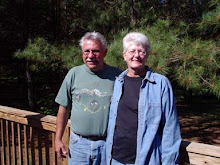
On the bridge . . . . . . . . . . . . . . . . . . . . . . . . . . . . The ferry to Mackinac Island


The Grand Hotel - Mackinac Island

And this one is my favorite - isn't it beautiful??


We stayed the night at the Little Brevart Lake North campground. We wanted to stay at the South campground but missed the entrance so continued a little farther. It is a small campground, only 20 sites with no hook-ups. The Little Brevart Lake is a very small lake, but very picturesque. The only banks on the lake are where the campgrounds are. Other than that it is lined with trees.


As I stood on the bank and looked across, I saw what appeared to be an "alligator" swimming. Now wait a minute - they don't come this far north, so I looked again and I am pretty darn sure it was a snake. Whatever it was it stayed like this until I got a picture of it and then disappeared from view. H-m-m-m interesting!


Traveling through the upper peninsula of Michigan is interesting from the viewpoint that it is mostly wilderness with a few small towns to pass through and of course, the glimpses one gets of the land-locked Great Lakes. Lake Michigan is on the south and the coastline is spectacular. What grabbed my attention the most was the color of the water. You would think this far north, the water would be dark and forbidding but it is the opposite. It reminds me of "blue water" that you see in Florida - green in the shallow parts, darker bluish-green as it gets deeper and above all else, so clear you can see the rocks on the bottom.


On the north side of the peninsula is Lake Superior which is a different color from Lake Michigan. Again the shoreline is spectacular and the color of the lake is a light blue going into the deeper shades of blue as the water deepens. Again, this lake is also very clear. Off in the distance you can see the Keewenaw Peninsula. On this peninsula is Michigan Technical University in Houghton, 2 copper mines and one or two ore mines.


As we head west we have seen 2 swans, 2 turtles and three deer. The cemetaries all have one thing in common - aside from the headstones - they are blanketed with flox - pinks and purples. It looks like someone covered the plots with a carpet of color. The white birch and aspen trees are just starting to leaf out and we have spotted daffodils in bloom - spring has finally arrived in the Upper Peninsula of Michigan. We are traveling through the Gogobic Iron Range into Wisconsin. See you there next time.