Valdez to Delta Junction, AK
When you go south in Alaska and you then want to go north, you win d up traveli
 ng the same road in both directions. So . . . today we are seeing the same things we saw on the way to Valdez, only now we are heading north. It is worth the return trip as the views are so beautiful. We have seen so many mountains, rivers and creeks on this trip it is hard to believe that one state has so many. It seems every
  few miles we are crossing over another body of water, all of it rushing somewhere beyond where we can see.
When you go south in Alaska and you then want to go north, you win
 d up traveli
 ng the same road in both directions. So . . . today we are seeing the same things we saw on the way to Valdez, only now we are heading north. It is worth the return trip as the views are so beautiful. We have seen so many mountains, rivers and creeks on this trip it is hard to believe that one state has so many. It seems every
  few miles we are crossing over another body of water, all of it rushing somewhere beyond where we can see.
We are staying tonight at the Sourdough Creek BLM Campground on the Gulkana River. There is a trail the creek but we opted not to take it. The Gulkana River is part of the National Wild and Scenic Rivers System managed by the BLM - Bureau of Land Management. Both the river and the creek have good fishing in
them.

New day and we are still heading for Fairbanks, but we will only get to Delta Junction tonight. Along the way at Meier's Lake we saw 8 Trumpeter swans, a bald eagle and the Black Rapids Glacier. This glacier was nicknamed the Galloping Glacier when it advanced more than 3 miles during the winter of 1936-37. It is currently a retreating glacier with little ice visible.

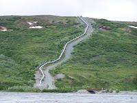
We again were able to access the Alaska Pipeline at the Denali Fault/Pipeline Visitor Viewing Area. The signs give the pipeline history
 and detail design solutions used to make the pipeline earthquake-proof. The zigzag pattern often seen in the above-ground sections allows for pipe expansion or contraction due to temperature changes or movement caused by other forces, such as earthquakes. The pipeline has an earthquake detection system. Ground accelerometers at pump stations measure earth movement and computers identify critical supports, valves and other items to check after a quake. The pipeline's design was tested in November 2002 by a 7.9 earthquake.
Delta Junction - population 984. Named after the nearby Delta River, Delta Junction began as a construction camp on the Richardson Highway in 1919 (it was first known as Buffalo Center because of the American bison that were transplanted here in the 1920s.) This is a pretty good size farming community and the farms range in size from 20 acres to 3,000 acres. The average farm is about 500 acres. Barley is the major feed grain grown in Delta. Other crops include oats, wheat, forage, pasture, grass seed, canola, potatoes and field peas. There are also small-scale vegetable farms, dairies, beef producers, swine producers, bison, elk, reindeer, yak and musk-ox ranches. Fort Greeley also contributes to the economy as it is located 5 miles south of the junction. It was deactivated in 2000, and reactivated in 2002 as a national missile defense site.
We ate at the Clearwater Lodge - just a hop, skip and jump from our campsite at the Clearwater State Recreation Site and this place was straight out of "Men in Trees", a TV show a couple of years back that was set in "Elmo, AK" a fictitious town. It was great - and the food was delicious.
Tomorrow we hope to make it to Fairbanks where we will meet up with John and Fran for the solstice festivities.


No comments:
Post a Comment